Bicycle Ride around Lake
Okeechobee in South Florida

Lake
Okeechobee’s Scenic Trail (L.O.S.T.) was once again the goal for us when
planning a longer bike ride. Since last summer Jill and I have ridden almost
3000km on the Santana Sovereign Tandem and we really like it. We had not
been out on the levee with our own tandem, so this time we wanted to see
whether we could go all around the lake.
Saturday,
March 1, 2008
We
start relatively late at around 8:30am. After a 1hr drive out to the lake from
our Palm Beach Gardens home we arrive at the Paul Rardin park and set up the
tandem (I’m still amazed that it fits inside of my Ford Freestyle with only
taking the front wheel out).

This
park provides a nice gateway to the L.O.S.T., the relatively new paved trail on
top of the levee around the lake. There are clean facilities and one can easily
park the car there during the day. From the top of the levee the view is quite
nice.

At
about 10:00am we are ready to start, a fairly late start for such a long ride.

We
have been here before a few times, including in March last year w/ Jon and
Karen Schaubhut when preparing for the South Florida MS 150 ride later in April
that year. So we already know the first 50km or so.

The
wind is NE with ~10mph, so we get a bit of a tailwind at the beginning.
Everything is fine and we start getting into a good rhythm.

Soon
we get down to the turn of the levee near South Bay, where we will go pretty
much straight to the East. We observe the traffic on Hwy 80 some 25 ft below
and at a safe distance of maybe 200 ft. A bit further along near Clewiston we
pass some burning fields freshly harvested of sugar cane.

The
smoke rises up and forms some Cumulus clouds, quite interesting to study the
different winds at altitude. Here we are on the downwind side of the lake,
hence no thermals in this area. In fact, the Cu clouds indicate the lake shore
during the day, with a big blue area in the sky directly over the lake.

Apart
from the occasional detour down from the levee to cross some canal and
circumnavigate a boat lock, the levee offers long straight lines with sweeping
vistas of the surrounding marshland.

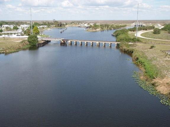
Soon
we are approaching Moore Haven where the levee ends and we need to cross the
bridge over the Caloosahatchee river – one of two tall bridges today.

From
the top of the bridge one has a good view of the canal and the surroundings.
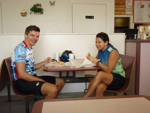
We
are now entering Moore Haven where we will stop for lunch, after all it is
already noon after about 50km ride.

We
stop at Joey’s pizza parlor, not exactly a lot of choices here in this little
town, but that’s good enough for us right now. We get some sandwiches and soda.
After
this nice break we continue our ride. Just outside Moore Haven the road turns
North leading up on the West side of the lake. This stretch of the road is
somewhat boring, but at least the wind isn’t as bad as I was afraid it would
be. We still make good speed on the tandem. Then we see a new bike path which
hadn’t been here last time I was riding around the lake after hurricane Wilma
devastated South Florida in October 2005 (see here for that trip report). However, the
joy about the bike path doesn’t last long:

Makes
you wonder whether this was tax payers money well spent in the first place.
Here we don’t see any bike rider, certainly there will be very very few to go
all the way around the lake.
Another
sad sight is that of a dead Bobcat on the side of the road. I have never seen
this fairly big cat in the wild, and I’d rather not see it when it’s dead.
We
both need a quick 5-min rest so we just pull over in the middle of no-where and
enjoy a quick power-nap.

The
100km mark rolls around at 2:30pm. We’re a bit behind my 100km per 4 hrs
rule-of-thumb timeline, so we can’t afford to linger too much anywhere, as the
sun will set around 6:30pm.

We
cross the Kissimmee river and enter Okeechobee county. After a little while we
can get back on the levee. Up here is probably the hardest part of the ride, as
we go directly into the wind and we’re both beginning to get quite tired.
We
stop at a little park bench which reminds me of many previous rides:

I
was sitting here both on the Orlando - Palm Beach ride in April
2007 as well as on
the lake circum-navigation in October
2005.
There
are a few more clouds and at times it almost looks like it could rain a bit,
but it stays dry. The temperature is perfect today, mostly in the lower
seventies, never really uncomfortably hot. As a result, we’re alos not drinking
as much as we had prepared for.
We
re-plenish the water bottles with some gatorade and snack on some salty peanuts
and cereal bars at a nearby gas-station. After that we get back on the levee.
There we struggle with the wind which is blowing from the side and prevents us
from going fast. In fact, the wind whistles in the spokes of the bike and
really makes us work hard. Backs, bottoms and legs start to hurt. Not much
choice for us, as we need to do another 50km or so to get back to the car…

A few pretty homes lign the canal behind the
levee, other than that there is not too much to look at. If I had eyes in the
back of my head, this is what I would see:

Then
at 5:00pm we get to the second tall bridge at Port Mayaca near the Eastern-most
point of the lake.
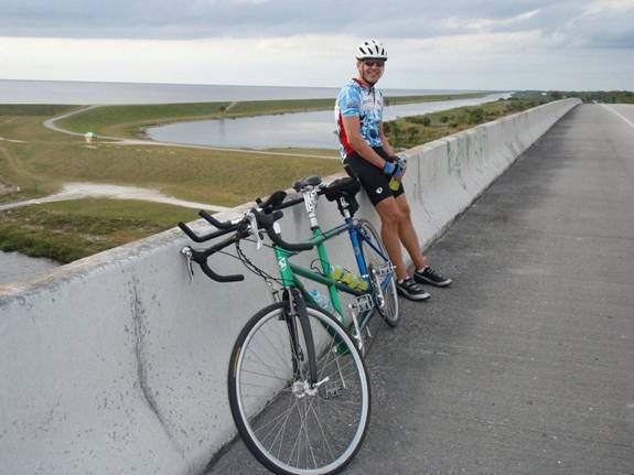
A
10 min rest up here at least gives us some great views of the surroundings,
while the occasional truck roaring by makes the entire bridge vibrate up &
down.
What
follows is probably the worst part of the entire ride, as for the next 15km or so
there is no levee and the road is very rough (in the process of being
re-paved). Jill laments the fact that the bumps in the road don’t help the fact
that she’s already in considerable discomfort. Furthermore she can’t see the
road ahead, so she can’t brace for the next bump coming up.
Every
bad stretch has an end, so in Pahokee we get back up on the levee.

There
is a trailer park here, and the sun is very low already at 6:00pm. We have
another 15km or so to go, so we keep going. The sun is sinking low on the
Western horizon and creates nice reflections in the lake towards the West.

We
reach another gate on the levee, one of perhaps two dozen or so that we need to
navigate. There we stop for a few more sunset pictures.

In
the pink glow of the evening sky we see a couple of fishing boats, just like we
had seen all day along the canals following the levee.

A
few more minutes and we are back at the car. We freshen up a bit at the park’s
facilities and I load the bike back into the car. After 8.5 hrs we clock about
185km (114miles) – following the levee w/o taking the slightly longer course of
the main roads means a bit less than 200km. Glad to be back at the car after
6.5 hrs ride time - quite a long ride indeed!

On
the way home Jill remembers something about an Indian restaurant in West Palm
Beach on Okeechobee road (true to our destination today) and finds it on her
BlackBerry. There we enjoy some excellent Indian food which we deserve after
this long ride J
