Sunset on King Col, 4150m, at Mount Logan expedition 2009:
Large crevasse above King Col at 4700m on Mount Logan:
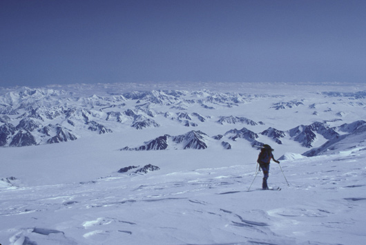
Arriving at Camp 3, 4850m, above crevasse on Mount Logan:
Ski descent from Camp 4, 5250m, to Camp 3 on Mount Logan:
Reaching the summit of Mount Logan, highest point of Canada:
Mt. Logan Facts (copied from my friend Zoran Vasic’ expedition page):
Height: 5959 m (19551 ft)
Location: Yukon Territory, Canada; N 60�33′ 60.0″ W 140�24′ 14.4″
First Ascent: Tuesday June 23, 1925 A. MacCarthy; H. Lambar; W. Foster; N. Read
Mt. Logan is the second highest in North America.
The Logan massif rises about 3000 m from the surrounding glaciers and has the largest base circumference of any mountain on Earth. A glaciated plateau, about 20 km long and 5 km wide covers the top of the massif. About a dozen peaks rise from the plateau – the highest, being Mount Logan’s main summit.
Due to its proximity to the Gulf of Alaska, severe snow storms can hit the upper part of the mountain any time of the year. The climbing season is from late April to early July. Generally, the weather deteriorates as the summer progresses. Springtime winds can exceed 160 km/hour; temps on the glacier can range from -40� to +80� F.
The mountain is normally accessed by ski-equipped aircraft or helicopter.
I was surprised to find only one expedition going to Mt. Logan in 2009. There are 50-100 times more people on Denali than on Mt. Logan. Denali is part of the Seven Summits and in some years more than 1000 climbers reach the top. On Mt. Logan, there are years where nobody stands on its summit! It is the most remote place I have ever visited.
We were a small and completely self-sustained team with 3 clients and 2 guides. We brought food and fuel for several weeks; if the weather turned bad, we would have to wait and hunker down. We can’t get off the mountain unless the weather is suitable for flying. Hiking out doesn’t appear to be an option, probably a 1-2 week journey through no-mans land in itself.
There are very little technical difficulties on the Kings Trench route. We ascended using skis and roped up for glacier travel. The main challenges here are the extreme cold and high altitude. I can now say that Mt. Logan is likely the wildest and most remote of all Panamerican Peaks!
Additional Notes:
Sunday June 7 – Day 1 Fly in from Talkeetna to Base Camp (2100m) by about 6:30p; setup camps.
Monday June 8 – Day 2 Move up with all gear to Camp 1 (2300m) along the Kahiltna glacier. Weather supposed to deteriorate tonight, but we still had sun in evening to set up camp. Met several folks coming through camp who did summit yesterday.
Tuesday June 9 – Day 3 Carry food and high altitude gear to cache at 3000m. Clear day, no clouds in the sky. 1014mb. Hot during ascent, nice and sunny upon return after 8 hrs.
Wednesday June 10 – Day 4 Today we move up to Camp 2 (3300m); 7.5 hrs moving up slowly. Set up tent at camp 2, very hot, sunny and no wind. 1010mb.
Thursday June 11 – Day 5 Backcarry of cached food and gear from 3000m up to Camp 2 at 3300m. Rest day. Good and plentiful food. Sleep at 30C+ in the tent. Try to stay out of the sun, brutally hot radiation. (unfortunately my tentmate is sick and coughing a lot…)Weather is supposed to deteriorate for the next two days, then clear again over the weekend. Concerned to see barometer continue to fall down to 1005mb.Talking to friends in camp, incl. two Austrians Wolfgang and Guenther as well as three Americans Al, Dan and Paul.
Friday June 12 – Day 6 Plan to carry food and fuel to near next camp at 4000m (past “windy corner”). Barometer sank to 1001mb!After normalization that is 1011mb. Cached food and fuel after windy corner. Descended to camp 2 again, unexpectedly hot.
Saturday June 13 – Day 7 Moved up to camp 3 (4350m). Hardest day of expedition so far. 1000m gain, break down and setup tents, 5hrs 20min. Very heavy backpack and pulling sled on steep terrain. Rest of group came up 2hrs 30min later!After windy corner again unbearably hot. Cloudy, just a few glimpses of headwall and steep terrain up to next camp.Barometer stays at 1011mb all day. Forecast is for high pressure building over the next 2-3 days.
Sunday June 14 – Day 8 Still unusually mild for Denali, only -5C in tent overnight. Slept on & off until 10:30am. Group brunch in cook tent. Good view of ascent route and fixed ropes on headwall – very impressive!Backcarry from cache past windy corner. Mostly restday.
Monday June 15 – Day 9 Temp at -10C overnight in tent. Barometric pressure at 1012mb.Rest day at camp 3 (4350m). There was an option to carry and cache to the top of the fixed lines today, but the guides decided to make today a rest day. Somewhat frustrating as there is nothing to do, I feel rested and strong, the weather is good and many other teams are moving up higher. Not only does one abdicate decision making to the guides, but you’re essentially stuck at camp with nowhere to go! Some sobering developments yesterday when they lowered an incapacitated climber down the headwall (HAPE) – this climber is fine again today. Also, just a few days ago two climbers tripped in a steep coulour and fell to their death while some folks from camp 3 were watching. (This was a case for two body bags!) Reminders that this is a serious mountain!
Tuesday June 16 – Day 10 Temp -10C in tent overnight; 1009 mb; wake up at 5:15am for early breakfast and 7:00am departure up the face and headwall to cache food on top of the fixed ropes. Temp -20C in morning which made for a chilly start, but better than to sweat up the hill in the afternoon heat! Great views from the ridge and no problem ascending the fixed ropes. One team member (Richard) had to turn around with guide Kurt, though. After return around 2:00pm rest during afternoon. (almost a rest day)
Wednesday June 17 – Day 11 Temp -6C in tent, light snow evening and overnight, 1007mb; Rest day which is challenging in it’s own way as your metabolism and mental state of mind is wired for high activity and you’re forced to lay around in the tent all day! Talked to the two Austrians Wolfgang Fasching and Guenther Weixlbaumer who returned from the summit (Tuesday) and stayed in camp 3 tonight due to clouds and snowfall; they now have 6 of their Seven Summits. Makes me wonder again how much faster I could have done Denali outside of the expedition…
Thursday June 18 – Day 12 Wake-up at 5:00am. Plan is to move up to Camp 4. However, during breakfast at 5:30 we learn that one of the guides (Lee) is sick and can’t go any higher today! This means the entire group isn’t going anywhere today or anytime soon! Change of plans – likely we’ll be stuck in camp 3 for several more days 🙁 (Perhaps this brings a shot at better weather for the top?) Serious thoughts about the suitability of a 12 member expedition for me on this mountain… Guide Kurt descends late evening with sick guide Lee and client Richard. Temp = -20C, around -10C in tent overnight.
Friday June 19 – Day 13 Another rest day at Camp 3. The sun hits the tents at 9:30 and immediately warms them up by 20 C. Due to the closing weather window I decide in the afternoon to leave the group behind and go up to Camp 4 (17.000). Weather is still good up here (1011mb), but low pressure is supposed to arrive over the next two days. Thunderclouds North of mountain. I dig out the guides tent from the AAI cache and set it up for the night. The guides called the Park Rangers so they tracked me down and I can’t continue by myself.
Saturday June 20 – Day 14 Temp -23C in tent overnight! Barometer down to 1006mb. Plan to descend again to camp 3 (14.000) with 3 guys from Nevada (Al Tattersall (atatters@hotmail.com), Dan, Paul) and then rejoin the AAI team.We set out late (14:00) but make it down in 2.5 hrs. Headguide Forest isn’t mad or anything, but suggests that I descend with another group. So I don’t know what to do. On one hand I’m burnt out a bit, on the other hand Denali is so close, and coming back at a later time would be a huge additional effort… I decide to go down with the Nevada group early the next morning.
Sunday June 21 – Day 15 (Fathersday) Wake-up at 3:30am and ready to move with Nevada team by 4:30. (Unfortunately 1hr delay and waiting in -20C cold and wind… Start to move down the moutain, first to camp 11.000, then the normal route down South… Walked all the way out to Kahiltna airstrips in 11.5 hrs, arrived at 4:30pm. Unfortunately the weather is too bad to fly so we have to camp one more night right at the airstrip near base camp. The Nevada team has two tents and let me share one tent for the night. We all sleep like babies for 9 hrs straight.
Monday June 22 – Day 16 We wake up to almost a foot of fresh snow. After digging out the tents we await our flights out. We are all asked to prepare the runway by walking on the fresh snow and are happy to see the planes land. Flight out to Talkeetna. Return of rental gear and chech-in at Hostel for a shower and to dry off my gear and clothing. Huge breakfast with the three friends from the Nevada team.
As every mountaineer knows, there is usually a limited time in the year when you can climb high peaks. Depending on the hemisphere and local climate, this usually is in the summer (higher latitudes) or in the dry season (near equator). Climbing a 6000m peak in winter or in the rainy season is much more extreme, more risky, less rewarding (except perhaps to avoid crowds), and in general not really an option.
In the excellent book “Climbing: Expedition Planning” authors Clyde Soles and Phil Powers have listed the prime climbing seasons for all major mountain ranges world-wide. From this I was able to generate a pattern for the peaks along the Panamerican route as follows (grey bars represent good months):
Prime Climbing Season for Panamerican Peaks
I started planning. Beginning in the North in late spring / early summer and assuming a certain average daily distance on the bike and the time spent on the various mountains, I ended up with the following pattern (yellow = within 1 month of good time, red = bad time):
Peak climbing times with original itinerary
As you can see, while there were a few peaks that fit, two were borderline (Mexico’s Orizaba and Chile’s Ojos del Salado), and three were way outside the possible climbing season: Peru’s Huascaran, Bolivia’s Nevado Sajama and Argentina’s Aconcagua! No amount of tweaking the daily distance or start time or other parameters seemed to work within one year. I didn’t want to skip any mountain. I didn’t want to extend the trip beyond roughly 1 year. What to do? I was stuck.
After some thought I had a different idea: How about riding in the Northern summer from Alaska down to Central America for the first half year, and then in the Southern summer from Patagonia up to Central America for the second half year! While this is not the original all-in-one-direction bike route, it does solve the climbing season puzzle and allow for a much better fit. My current plan looks like this (bottom five rows in reverse order):
Peak climbing times with new itinerary
There are no red zones and both Canada’s Mt. Logan and Chile’s Ojos del Salado are close to the good season. So I should have a reasonable chance of possible weather conditions for most if not all peaks. Note that I also swapped Mt. Logan and Denali at the beginning. This decision was due to the scarcity of expeditions offered on Logan. The number of climbers on Denali is about 50-100 times higher than on Logan (Denali is part of the Seven Summits, Logan is not). Consequently, there are many expeditions every week for several months on Denali, while on Logan I only found this one in 2009!
Now purists might say: “This is not the classic Panamerican Highway ride, you need to fly from Central America down to Patagonia, and the sequence of peaks doesn’t match those of the countries on the map!” And guess what, they are right! But that’s the best I could come up with. After all, this project has never been done before, so there is no template or blueprint. Finding a solution for problems like this is part of the challenge. As long as I ride the entire distance (except for the Darien Gap) and make an attempt on all peaks I am satisfied. Perhaps others will find a better solution for the peak puzzle…