Archive for August, 2009
(Quick note: My SPOT tracking should be back on tomorrow, Thursday Aug-27. Also, I updated the US ride page, Washington section and created a photo gallery for Washington.)
I just crossed the mighty Columbia River over to Astoria, Oregon. This concludes my ride through Washington State. Here are a few impressions, both from the vacation trip with Jill (Olympic NP) as well as the last three days of riding to and finally along Pacific Coast Highway 101.
Olympic National Park is one of the finest parks in the US – it has so much variety: High mountains with glaciers, remote wilderness and wildlife, temperate rainforest with giant, old-growth trees, and ruggedly beautiful Pacific Coast. It is worth more than one trip, as it’s impossible to really see everything here in just a few days.
After resuming my ride from Bellevue I first need to get over to Seattle. There are many bike paths, so it’s not too bad. Still, riding near downtown Seattle is quite the contrast to the lonely stretches up North in Yukon and Alaska…

From Seattle I take a ferry across Puget Sound to Bermerton. This way I escape the traffic South of Seattle, Tacoma and Olympia.

Beautiful scenery along the Hood Canal and two memorable stays at the Potlatch State Park and later the Twin Harbor State Park near Westport.


More fresh Blackberries along the way – oh it’s good to ride in berry season! Finally the Columbia River crossing across the Megler bridge is pretty cool, some 6.5km and a good hill climb, very scenic but also very narrow shoulder…

Astoria has charm with all it’s piers and restaurants; also the bridge and the Ocean-going vessels are something you don’t see every day!

Now I’m looking forward to the Oregon Coast!
August 27th, 2009
Short update: After a 2 week vacation with my wife Jill in the Pacific Northwest I am now resuming my bike journey South along the Pacific Coast. We spent time kayaking and hiking on and around Vancouver Island, the San Juan Islands, the Olympic NP and Mt. Rainier NP. Except for the rainy beginning we enjoyed the sunny weather so typical for August in this area.

We also rented a tandem bicycle on San Juan to explore the Island, a popular bike destination. One highlight was a ride to the West Coast (Lime Kiln State Park) where we got to see many Orcas passing by at various distances to our shore line, the closest maybe 200m away from where we were watching. We had seen dolphins on our tandem rides in Florida, but seeing Orcas in the wild here in the Haro Straight between San Juan Island and Victoria on Vancouver Island was a real treat. Also nice sunset mood from the South end of San Juan (near American Camp).


Today I’m taking care of some errands and then will be leaving the Seattle area in the afternoon. Look for more Blog updates in the next couple of days.
August 24th, 2009

After spending the last night in Canada camping under some tall Douglas Fir trees along the Fraser river I needed to ride from Hope to Chilliwack and then to Sumas. One of the two choices on that route is the Trans Canada Highway 1. While it is perfectly legal to ride a bicycle on this highway in most sections, it is not exactly a pleasant or very safe experience. I felt like riding on an Interstate, with the deafening noise of passing trucks being the most annoying aspect.

By contrast, once getting off the highway, the road leads through idyllic farmland, with the sounds and smells of summer everywhere. The occasional blackberry bush satisfying my cravings for fresh fruit and sugar.

After 60km I reach the town of Chilliwack and stop there at the visitor center. I take a long break at a Best Western restaurant for a late lunch and to do email. I also meet Rill and Marvin, a couple passing through on vacation, who take interest in my bike and journey.
I continue on via the smaller roads zig-zagging through farm fields towards the SW and the border town of Sumas. A few dogs chase me, but only one Rottweiler comes out to the middle of the road and forces me to stop. Maybe I’m getting some use of the Bear spray after all?
It’s already getting late and the sun is sinking lower and lower – seems like I’m getting a bit rushed due to the fading daylight after all. At 99km I reach the border. A friendly customs agent asks me a few questions and does some paperwork. 10 minutes later I’m back in the US and continue riding South. The sun is setting now with a nice display of a red ball sinking down in the corn fields. I still want to reach the campground in Lynden some 10km further to the West. It’s 9pm and nearly dark when I get there. Luckily there is a plaza with restaurants not far from there, so I get some pizza and a glas of red wine there to celebrate the completion of the Canada section of my ride.

I spend the next 1 1/2 days riding South on Highway 9 towards the Seattle area. There are a few rolling hills, some lakes and not a lot of traffic until you get to Everett some 50km North of Seattle. The ride is uneventful and relatively easy (not a lot of hills, except towards the end in Bellevue). I stop frequently for fresh breakfast, to pick backberries right next to the road, and for good lunch or coffee. Each day it seems to get another 5C cooler and wetter. On the last day I start out in very low, thick clouds with light drizzle – good thing I can warm up on the first 80m hill right after my start in Arlington.

I’m using the iPhone GPS for navigation into the city. A nice stretch comes along the Samamish River Trail, where there is no motorized traffic. At last, on Friday (Aug-7) noon I reach my friend Karl’s place in Bellevue – haven’t seen Karl in about 2 years… Great to finally be here! And I still find it hard to believe that I rode every single meter all the way from the Arctic Ocean down to Seattle!
Now I look forward to a 2 week vacation with my wife Jill out here in the Seattle / Vancouver region. Some kayaking and hiking will provide a welcome change from the strict bike riding regiment. My recumbent bike will be resting at Karl’s place, waiting to resume the long ride South in 2 weeks…
August 8th, 2009

The title of this post is not a democrat-leaning political statement. Rather, yesterday I rode from Clinton in BC down South through the Thompson and then Fraser River canyon all the way to Hope, BC. That’s 240km in 11h and 2400m vertical. By far my longest day, assisted by an initial long downhill and good tailwind for the first 5 hours.
I had started very early, hitting the road at 6:15am. The air was much cooler, hardly any traffic, and no more smoke so it was a pleasure to breathe. (It had made a lot of sense yesterday afternoon to stop in Clinton and wait out the bad traffic and smoke.)

The first hours were easy and fast. A net 650m drop in elevation and the tailwind often made me feel like a motorcycle rider, almost effortlessly dropping down to the Thompson river at speeds up to 74km/h. 100km at noon with a 25km/h average, what a blast! Reminded me of the long tailwind-assisted dayrides in Minnesota. And made me think about whether maybe I could reach all the way down to Hope in one push!
At 150km the tailwind shifted to headwind – this was definitely not part of my ambitious plan! It may have something to do with the confluence of the Thompson and the Fraser Rivers? Anyway, as a result, I also got very different air filled with fire smoke, which made breathing harder and the whole thing more unpleasant.

And I had to work hard again for the many hills. At times the road drops down right next to the river, allowing to see the rafts up close. Occasionally the road would cross over the river and over/under the railroad line. Only to climb up another 100-150m around the next bend in the valley! Such hills take 15-20min and a lot of sweat, plus the many campers and trucks add some unhealthy Diesel exhaust to the respiratory mix…
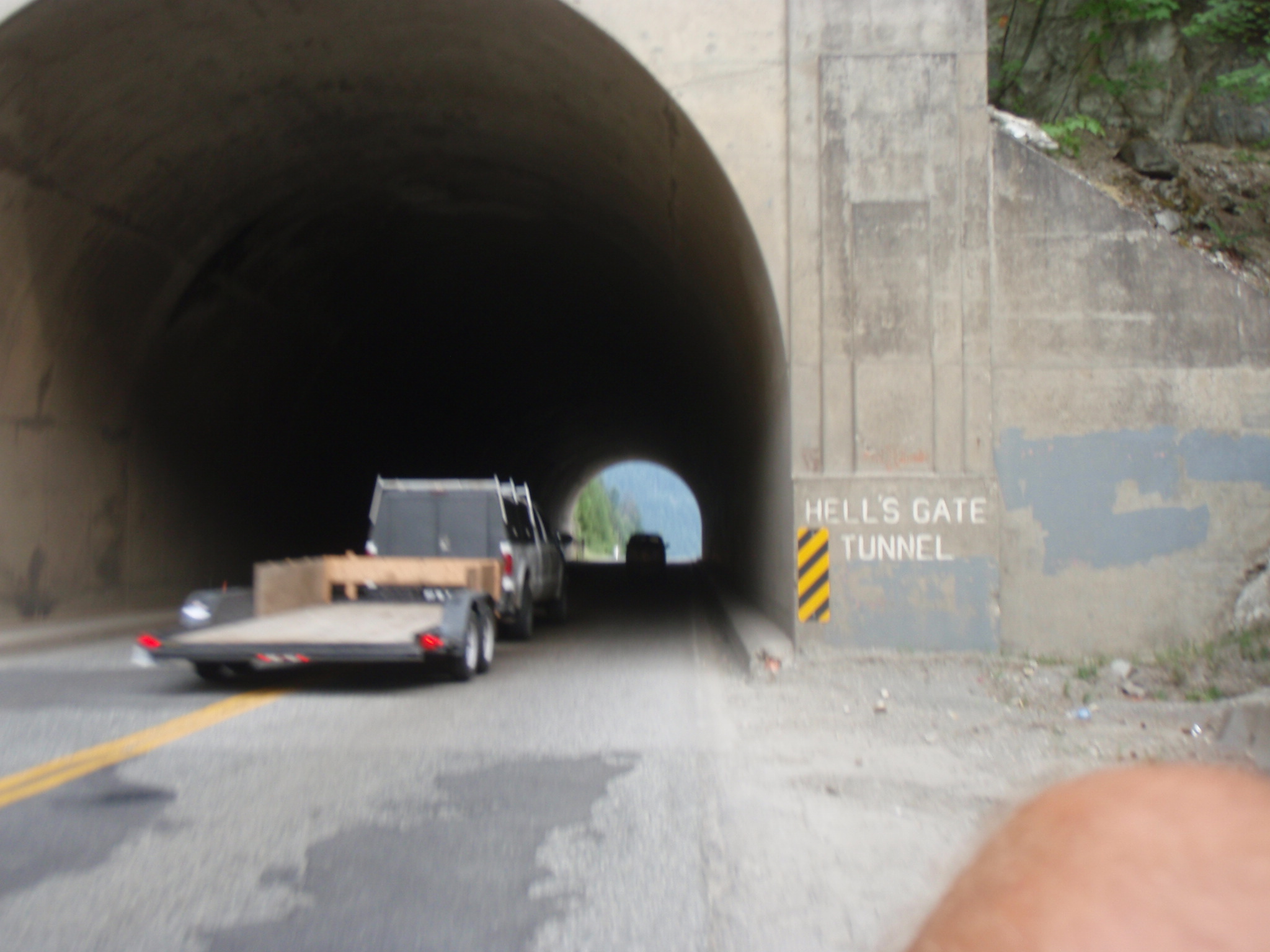
To make things worse, there were about a half dozen tunnels, all with jet-like headwind! They have you push these buttons for signal lights to alert motorist of cyclists in the tunnel. Good idea, except a few truckers still didn’t slowdown. There were some of those moments when you’re riding 2 feet next to the tunnel wall, can’t hear anything over the truck engine roar and can’t afford to mess up!
A short break came at what’s called “Jackass Mountain Pass” – no kidding, I have a photo to prove that’s the name. There is an overlook with a steep drop some 250m down to the river. I met and chatted briefly with a german couple, who took the picture.

At 175km I was in doubt whether I could do the entire distance. Only 3h of daylight left. But stopping right here in the canyon didn’t seem like a good option either. Eventually the wind died down around 210km and the last hour or so was better – good air again 🙂 Then one last 90m hill – boy do they hurt after 10.5h on the bike! – and a good downhill and a last river bridge right into town.

I ate a footlong sub at Subway as no restaurant was open at 8:45p anymore. The campground is excellent, with great showers, wireless Internet from motel across the street and right next to the huge Fraser river. My tent is under tall Douglas Fir trees and there are no mosquitoes 🙂 I am tired but very happy; the U.S. and Seattle have moved within close range!
August 5th, 2009

Yesterday I ventured away from the main highway and took two detours. One upon recommendation of Peter and Diana, who I had met and spent some nice time over dinner with the day before. The other one to find some camping accomodation in a nice nature setting away from the highway.

The first detour was just South of Williams Lake, where the main highway goes over a big hill and the old road meanders around closer to the valley bottom.

One of the things that slows me down here are the many cattleguards, which I am crossing very slowly and carefully:

Friend Peter lives out here and shows me the very idyllic place of his landlady, a house with an interesting history.

After riding a couple of hours on the main highway again I reach 100 Mile House and stop by at the Visitor Center. There I discuss several options for a nice place within reach for a stay overnight. One recommendation is to detour towards Green Lake. A look at the map makes this seem reasonable, with moderate extra km to go. It is getting late in the evening, so the sun is casting long shadows again.

Unfortunately the backroads here are very hilly, and I take a wrong turn once, having to backtrack a few km and vertical m. It takes me 2.5 hours to cover 35km, definitely longer than I expected. Hence I end up in a race against time due to the sun setting earlier. Speaking of sunset: At one point the sun sits bloodred just behind me in the rearview mirror:

Another half hour or so of tiring up-&-down riding brings me to Green Lake and the Little Horse Lodge. The scenery is very pretty, with the moon rising and some thunderheads glowing red in the distance.

My only complaint with this backroad detour is that the German restaurant at the lodge already closed at 8pm, 1 hour before I get there … and they had German dinner specials that night :-((
August 3rd, 2009
Previous Posts