Over the last two days I have hiked both the high point of El Salvador, Cerro El Pital (2790m) and of Honduras, Cerro Las Minas (2849m). Both peaks are in or near the Trifinio region (border of Guatemala, El Salvador and Honduras). To get there, I left my bicycle in Aguilares (El Salvador) and then had to do a lot of bus riding. Those bus rides are often the more adventurous part of the peaks in Central America – and they are not always safe (I’ll write a separate post about that soon.)
Cerro El Pital, El Salvador:
This country high point is probably the easiest to get to of all the Panamerican Peaks: The mountain has an antenna on its top and a regular road leading to a saddle not far from the top, as well as a 4-wheel drive track all the way to the top. There is also a camp ground just below the top, from which it takes only 10 minutes or so to reach the top. So this high point is not a mountaineering challenge at all.

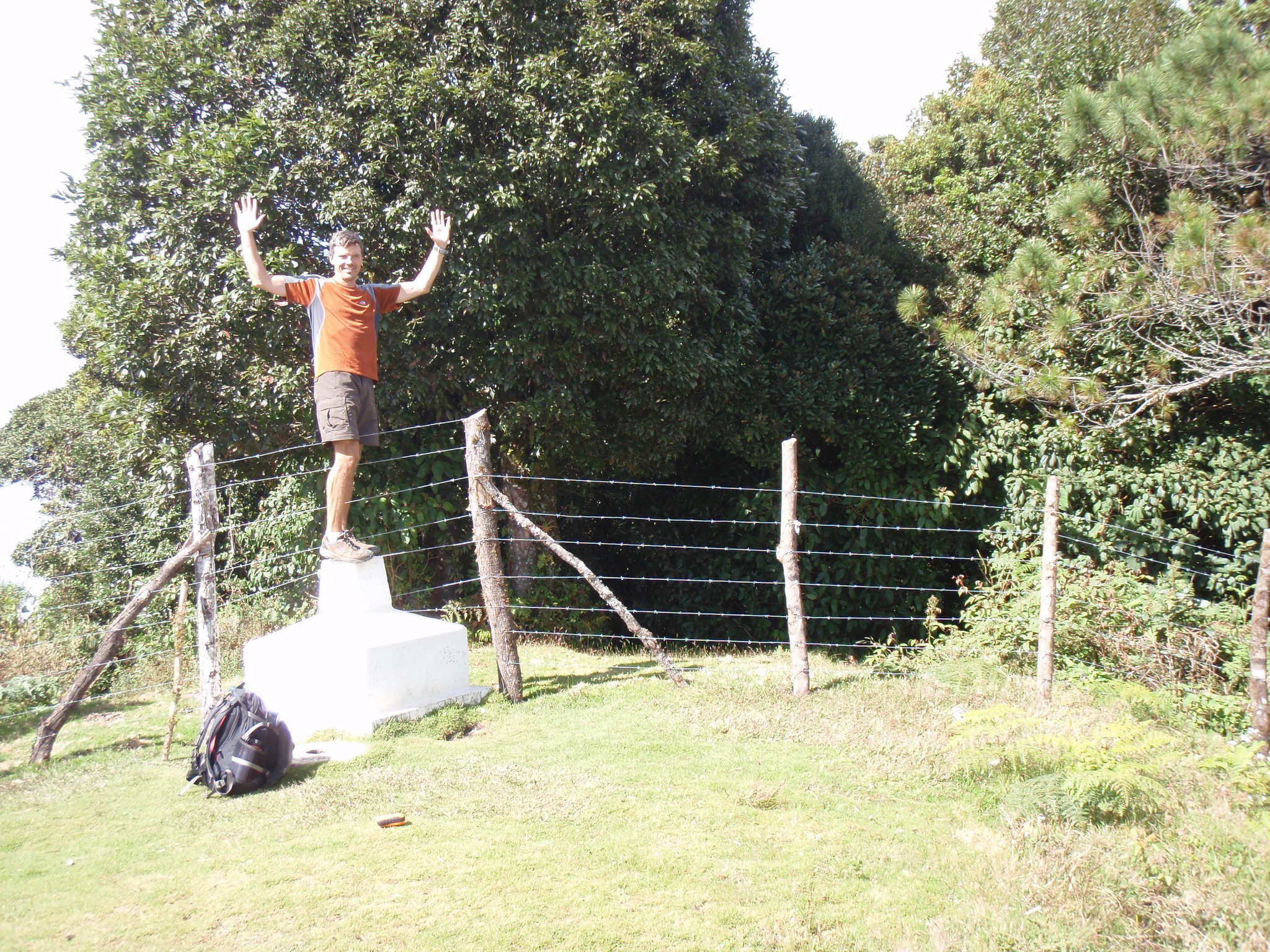
The marker on the summit marks the border between El Salvador and Honduras. You can stand with one foot in each country, even though nowadays you have to be willing to straddle a barbed wire fence…

I was lucky as I hitched a ride on the last 5.5 km section from the main road to the summit with a jeep convoy of some engineers doing hydro-geological development projects. This is a joint venture between Germany and El Salvador, so I got a detailed explanation in German from one of the project members!
After my brief visit to El Pital I continued the bus ride to the border, where I entered Honduras after just a few minutes of paperwork and without any problems. (I often have to explain to people and border officials, when they inspect my Austrian passport, that Austria is not Australia!)
Cerro Las Minas, Honduras:
I reached Santa Rosa de Copan after another 2.5 hr bus ride from the border. By now it was almost 7pm and there was no more bus to the valley of Gracias, so I had to stay in Santa Rosa for the night. In Honduras the currency is called Limpira, and you always get a bundle of paper for any significant amount (they have no coins).
In the morning I took the first bus to Gracias, where I arrived at 7:15am. From there it’s annother 10km or so to the entrance of the Parque National Montana de Celaque. The most convenient way to get there is by Tuc-Tuc. I arranged for a round-trip transport and paid 1/3 at the beginning, giving the driver a good incentive to show up in the afternoon to pick me back up.

The trail begins at the park entrance at 1400m, Las Minas is the highest point at 2849m. That wouldn’t be too bad, except the normal trail already has a lot of up-&-downhill, so you’re looking at about 2000m elevation gain. For a single day hike this is quite ambitious. I had barely 8 hrs, but I was going to make a run for it. The trail starts up through amazing cloud forest, very similar to what we had seen at Chirripo in Costa Rica.

I was really excited about the steep trail which followed a ridgeline and was at times a bit exposed. While you had to watch your step you also got some brief glimpses of the surrounding valleys – most of the time you were just completely surrounded by forest and couldn’t see anything.
After climbing almost 1000m I topped out on a highpoint of the ridge, with steep drops all around. This path wasn’t leading to Las Minas after all! What to do? I continued down 100m to a saddle, and the only path from there continued down. I followed that path for another 150m or so, just to make sure there wasn’t a connection to another path nearby, but it seemed to lead all the way back down again. I couldn’t believe it! I ran back up to the saddle and searched for another path towards the main summit. I scrambled through the dense forest, but without a path this is both very tiring, slow and dangerous. If you slipped and fell, nobody would find you off the path. Also, you can easily get lost. After 50m or so I gave up; just retracing back to the saddle was quite tricky already. I had no choice but to go down, which made me believe that I would run out of time (and energy) to reach the summit today.

About 300m below the ridgetop the trail intersected with the normal route. Even though I had done almost 500m extra and lost about 1.5 hr I now had a chance again; my summit bid was still on. I continued hiking very fast on the steep trail, reaching my limit. Every hour I stopped briefly for 5 min or so to drink and eat a chocolate bar, but the mosquitoes were so relentless that you wouldn’t want to rest any longer. After about 5 hr I reached the top of Las Minas.

Sicne the top is completely covered in forest you can hardly see anything, much less a panoramic view, which was a bit disappointing. There is only a small wooden board and a country flag nailed to a tree.

After about 10 min I started downhill again. I now had only 2.5 hrs to get down to the park entrance. The trail is often quite steep, which allows you to descend fast – if you’re surefooted and comfortable running downhill fast. However, there were also plenty of ascents to negotiate, down and up little creeks and waterfalls, past some camping areas, etc. Most people do this mountain in two days and camp up here. After 7h 45min I reached the park entrance again and we immediately started with the Tuc-Tuc back down so I could catch the last bus at 5pm back to Santa Rosa. If this sounds like a hectic schedule, it was! We arrived in Gracias with 10 min to spare, so the driver showed me the fortress. I gave him a good tip and was soon sitting on the bus back to Santa Rosa, where I had dinner and stayed for the night again.

2 summits in 2 days, 5 summits in little more than a month. Now I have 8 (of 16) peaks. There are only 2 summits left in Central America (Nicaragua, Panama) – after that it’s all in South America.
December 5th, 2009
Today I will leave my bike in Aguilares (30 km N of San Salvador) and leave by bus to the area of Cerro El Pital, El Salvador’s high point and then nearby Cerro Las Minas in Honduras. Both of them are less than 3000m, so no challenge from altitude there.
El Pital is not a mountaineering challenge at all, as there is a road up there and a camp ground 5 minutes from the summit! It’s more like a drive / walk in the park.
Las Minas, however, is more remote and has 2000 m elevation gain through the cloud forest, so this should be a real good hike.
As with Tajumulco, I expect the real adventure to be the various bus rides to get to the respective trails.
I should be back in 3 days. Check back for an update and photos soon!
December 3rd, 2009
Yesterday I started to continue with my ride through Central America. First I needed to cross Guatemala City, which had a lot of traffic and stinking vehicles in store for me.

In addition, I needed to climb about 400 m up to a ridge to leave the city which is situated in a bowl. This climb was very uncomfortable due to the heat and the many particles of the dirty diesel exhaust of the incessant traffic. I actually got a slight headache from this exhaust – probably not the best day for my lungs either 🙁

As a counterpoint, what followed was a fantastic 900 m (3000 ft) downhill on a great 4-lane road (the CA-1 Highway). I covered 20 km in 25 min, topping out at speeds of nearly 72 km/h, passing several trucks on the way down. The latent energy I had put into the bike on my last day of hard riding up to Guatemala City was now released and helped me to cruise effortlessly.
So it went up and down several hundred m two more times for the rest of the day. I almost got caught again in the dark on a 1.5 hr climb until 5pm. On the downhill the sun was setting and when I reached the little village of El Amate (between Cuilapa and Jutiapa) it was getting dark. I ate dinner at a small restaurant and luckily the owners told me that I could pitch my tent on their private property just a short walk from the restaurant.

The last night in Guatemala was quite noisy, with roosters, dogs, trucks, and some crazy locals in their cars seemingly competing for the most annoying noise. In the middle of the night at 3am someone pulled up next to the road some 100m away from my tent and blasted the area with super loud music from the car stereo – that lasted almost 1 hr! I put in ear-plugs and drifted into sleep again…
Today in the morning I had breakfast there while the tent was drying in the early morning sun. Then I continued with the ride towards the El Salvador border, now only about 70 km away. First stop was in Jutiapa, where I looked for and found an Internet provider to catch up on email (since I didn’t have Internet access last night). Then I continued with some hills for the remaining 50 km to the border.
Some local cyclists rode beside me in this area which was fun. Once I reached the border there were long lines of trucks lining the road for several km apparently waiting for the paperwork of the border crossing. I was getting concerned about such wait time, but it turned out that for me it took only about 15 min. The border agent first did his paperwork, then came out to have a picture taken from his cell phone while sitting on my bike, then I had someone take a picture with my camera as well. They all wished me well for the rest of my journey.

The remaining 35 km were first another 200 m uphill, then a sizeable downhill and lastly about 20 km of flat road. The latter provided a great way to end the day; riding on a flat road is just so much less strenuous…
I reached Santa Ana, the first town here in El Salvador. Near the center I found a hotel and got a room with shower and bathroom and Internet – all for just $12 per night. Here in El Salvador the currency is US$, so no need to collect yet another currency in my wallet…

Tomorrow I will continue riding towards San Salvador, from where I’ll probably take a bus to detour to the country high point Cerro El Pital on the following day…
December 1st, 2009

Link to SPOT track of Chirripo hike
The last two days Jill and I were up on Chirripo. It was a scenic and interesting, but also a very long hike. (See the photos on my Picasa web gallery.) The trailhead is at 1520m, the hut at 3400m and the summit at 3820m. The round-trip trail distance is 40 km (15km on day 1, 25km on day 2).

On Day 1 we started around 6:00am to take advantage of the first light and the relatively clear conditions in the morning. The trail climbs fairly steeply through the cloud forest and has markers for every km so you always know how far you still have to go.

We reached the “Base Crestones” hut around 3:00pm. This gave us some time to rest and check out the hut and nearby surroundings. Interestingly, the hut has the best drinking water in all of Costa Rica and free wireless Internet (hence I was able to tweet from the mountain)! We went to bed early (7:00pm) to catch some sleep prior to the next, big day.
On Day 2 we left the hut around 3:15am to have a chance at a clear summit. Due to the proximity of both Oceans (Carribean and Pacific) there is usually cloud build-up surrounding the summit by early morning. The remaining 5 km and 400m elevation gain was not too bad. We reached the summit around 6:30am and enjoyed a half hour of clear visibility in all directions over the top of cloud layers far below.

We got back down to the hut and took a short rest there. At 10:00am we continued our descent. Although already somewhat tired from the many km and the cumulative more than 2500m elevation gain in the last 28 hrs we now had a long way down ahead of us.
Around noon it started to rain; drizzle at first, then steady rain! (It’s not only cloud-forest, but rain-forest after all! And according to the locals this November was exceptionally wet…) We reached the shelter at Llano Bonito about half-way and had a short break and snack while it was just pouring down. But we needed to move if we didn’t want to get caught on the trail by the dark.

The rest of the trail was fairly miserable. For one, we were tired and our legs and feet began to ache and hurt. Then the rain and everything getting soaked added to the discomfort. Above all, though, the trail in the lower half is very muddy, and walking down through the slippery mud was extremely difficult and tiring. One had to be very careful not to slip and land in the mud.
This is also why we walked rather slowly and ended up hiking the last km in the dark with our head-lamp and flash-light. We were very happy to reach the trailhead by 6:00pm and shortly thereafter back to the comfort of a hot shower in our room at the Talamanca Reserve followed by a celebratory dinner.

I’m glad we reached the summit together. Chirripo is a great hike but very strenuous – probably nicer in the dry season. It goes to show that you can’t judge a mountain simply by the altitude of it’s summit. For example, Guatemala’s Tajumulco is 400m higher than Costa Rica’s Chirripo, but far easier – literally a walk in the park by comparison. Chirripo marks the 6.th Panamerican Peak and the 3rd within the month of November.
November 25th, 2009
Yesterday Jill and I arrived in Costa Rica at the Talamanca Reserve near the Chirripo National Park. It was a long journey to get here, after the flight and a 4.5 hr rental car drive over winding mountain roads and 11.000 ft high passes. Today we spent the day relaxing and also horseback-riding through the cloud forest to waterfalls.

Tomorrow morning we will leave for a 2-day hike up Chirripo Grande, Costa Rica’s highest mountain. I have created a SPOT tracking page (see link on the right). Wish us luck with the weather!
November 22nd, 2009
Next Posts
Previous Posts