Alaska
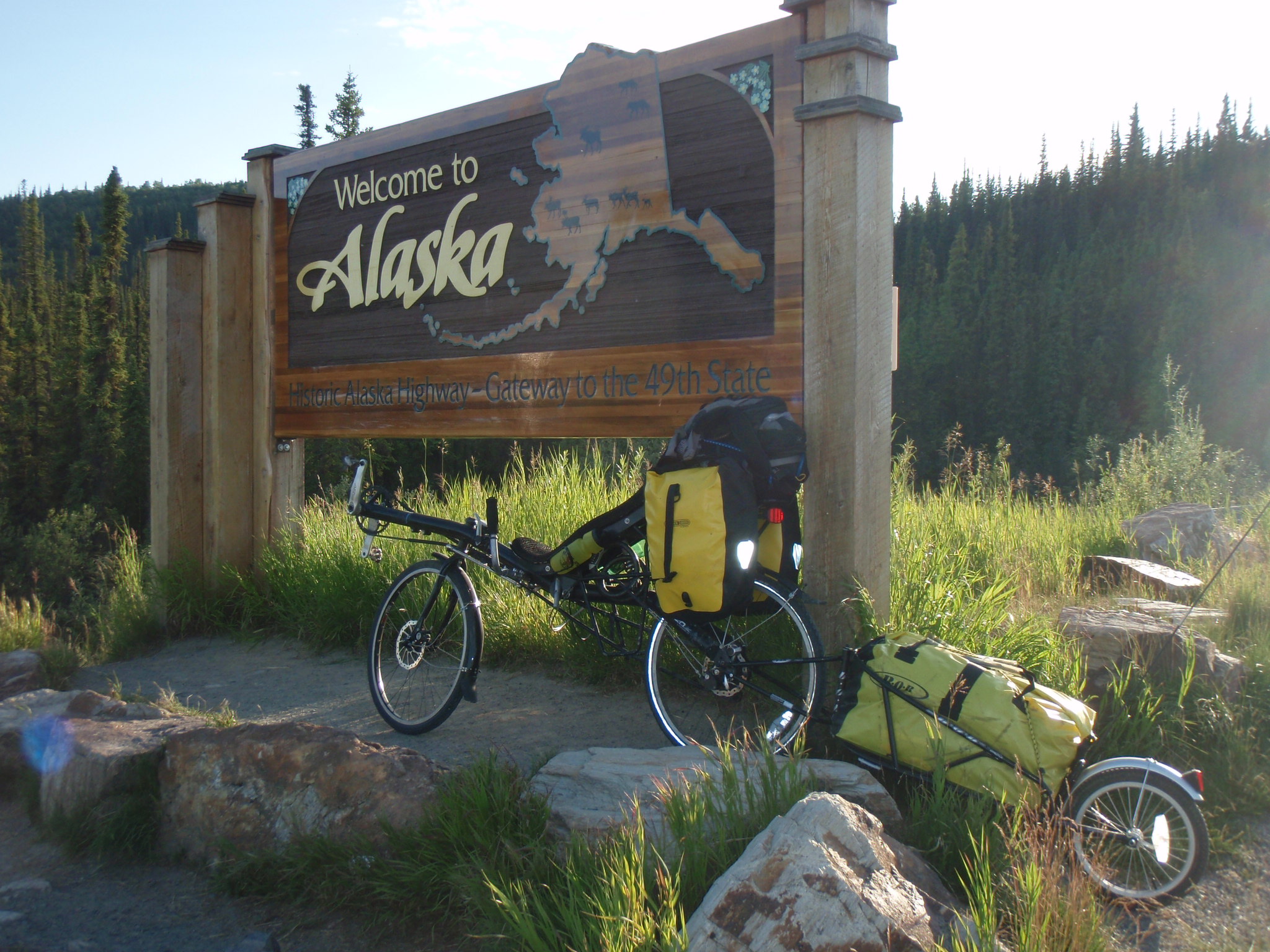
Summary: 10 days of riding; 7 days on the Dalton Hwy from Prudhoe Bay to Fairbanks, 840km, 54hr, extremely hilly (12.500m vertical), 2/3 on gravel, often very dusty due to heavy truck traffic, bothering mosquitoes, little wildlife (too much traffic!), less remote than expected, very friendly people, beautiful scenery, especially North of the Brooks range with stunning views of the mountains, clear lakes and streams and endless wilderness away from the road. Then 3 days of flat riding on Richardson Hwy (Fairbanks to Delta Junction) and Alaska Hwy (Delta Jct to Tok to Canadian border); 530km, 36hr, 4000m vertical; long stretches through boreal forest, some hills along Tanana and other rivers, very scenic late evening light.
Dalton Highway: Prudhoe Bay to Fairbanks
Photo Album of bus ride and bike ride along Dalton Highway (59 images)
Fairbanks to Canada
Photo Album of bike ride from Fairbanks to Tok and Canadian border (Alaska Hwy)
SPOT tracking page
Map created by SpotAdventures:GPS Geotagging
Dalton Hwy – Daily Travel Log typed on my iPhone (with info on distance and elevation gain):
Wednesday – July 1 – Day 1 Prudhoe Bay to Happy Valley Camp
135km, 950m vertical; 11:30 – 23:30; dinner from 20:00-21:00; First 90km gravel, at times very difficult and deep, once I pushed my bike in muddy conditions for 2km. Great help by pumpstation 2 guard Jason Shea, the German couple Markus and Jutta, as well as Jim Colleen ( at overlook during dinner). Met two other riders Matt and Bhatiste who are also doing the Panam Hwy. (Matt’s website is http://www.pedalpanam.com)
Thursday – July 2 – Day 2 Happy Valley to Galbraith Lake turnout
99km, total 230km; 1860m vertical, total 2810m. 7h ridetime (14km/h). Sore throat upon awakening at 7:00am. Breakfast cereal with milk courtesy the folks at Happy Valley! Tough first 30km with gravel and lots of hills; 2 hrs sleep at 40km pumpstation 3 (again Jason Shea who gave me water) and Aspirin.Matt and Bhatiste ride by and I pack my stuff and catch up to them. Lots of hills; some so steep that we have to push. Bhatiste’s d�railleur breaks so he can’t continue; however he hitches a truck ride within 1/2 hrs! Very scenic landscape in evening with Brooks Range close by.
Friday – July 3 – Day 3 Galbraith Lake turnout to Coldfoot
170km, 406km total; 1925m vertical, 4735m total; 10h ride time (16.5km/h), 25 total. 6:20am – 19:10pm 50km to Atigun Pass (1410m); last 2km too steep for me (pushing was hard work). Beautiful summer day, perfect weather, except early morning very warm. After Atigun Pass nice downhill sections; I wanted to reach Coldfoot for the dinner buffet, showers and nice campground. I put myself under time pressure to reach camp before the buffet closes at 20:00 – so the afternoon was very hard with only two short breaks to filter river water (turned into deliciously tasting Gatorade!). Unfortunately my throat still hurts and every now and then I’m coughing on the bike :- ( I was completely exhausted by the time I got to camp. Soup and Salad buffet, then setup tent, then hot shower, then meet & chat with Markus and Jutta one more time 🙂 in sleeping bag by midnight, nice cool air to sleep.
Saturday – July 4 – Day 4 Coldfoot – Arctic Circle
101km, 507km total; 1660m / 6395m total; 6.75h/ 32h total; Very relaxing start in the morning, breakfast at restaurant, visit to Visitor Center; gave a 15-20 pound bag to Joe the van driver to bring back to Fairbanks. This made climbing somewhat easier today. Also entire section of road is paved 🙂 rest at Grayling Lake and in evening at Gobblers Knob (after long climb). Got water from truck convoy, but unfortunately my fuel pump didn’t work :-(Beautiful evening sun, purple fireweed flower meadows, arrive at Arctic Circle camp at 11:30pm
Sunday – July 5 – Day 5 Arctic Circle to Hot Spot Cafe (near Yukon Bridge)
93km / 600km total; 1720m vertical / 8115m total; 6.3h / 38.3h total. Start at 9:10am; chilly downhill, but soon very warm on the many steep hills. 2hrs rest at noon at Finger Mountain after long climb. Very tiring hills, also end of pavement, but gravel comparatively good. Filtered water twice, then got water from Jitka, the Czech lady who drove up North to see the midnight sun… (had seen her at Gobblers Knob yesterday) Arrive at Hot Spot around 7:45pm and have Mushroom Burger and Milkshake for dinner 🙂 Met Josh and Rene who bike from Anchorage to Prudhoe Bay and were on day 11 of their tour.Tent on undeveloped campground, but great water from well right next to it.
Monday – July 6 – Day 6 Hot Spot camp (Yukon bridge) to Livengood (end Dalton Hwy, Elliott Hwy)
106km / 707km total; 2330m / 10445m total; 7.6 hrs / 46 hrs total. Start at 7:30am, short 8km ride to Yukon River Bridge / Camp for breakfast. Need to pass time (45min) as they only open up at 9:00am! Walk to Yukon river and to Alaska Pipeline display / interpretive center. After 4 pancakes with lots of butter & sirup I start a long uphill over the Yukon bridge and into the hills at 9:45. Plenty of hills, first 40km still paved; great mood, almost philosophical thoughts, thinking about opening chapter if book and about Jill and the “celebration of life” … Very nice long descent on great paved road, slow uphill… I get water from some motorcycle riders at a great overlook on a ridge. When I tell them about my project they take a picture of me and say: “One day you’ll be famous!” The km are ticking by, I almost see myself at the end of gravel and finishing the Dalton when 20km before I get a flat front tire at 30km/ h downhill! Luckily I can stop without crash, but the front tube got punctured many times after the initial flat! My repair kit doesn’t have enough rubber cement, so I can fix only 5 of the 6 holes :- ( waited for 1 hour, then motorcycle driver stopped and gave my supplies, thankfully I could continue!Reached end of Dalton around 8pm. After a few km on the paved road I see a campground sign; turns out this is only a normal parking lot, but at least we’ve got flat ground. Nearby I find water from a creek to wash off the dust and sweat, as well as to filter drinking water. Then I meet & greet with John – 79 yr old widower on fishing trip in camper mobil – he gives me hot water for my freeze dried food and invites me to sit in his camper for dinner, where we chat for about 1 hour.
Tuesday – July 7 – Day 7 Livengood to Fairbanks
130km / 838km total; 2105m / 12550m total; 7.6h / 54h total; I wake up when John starts his camper bus right next to my tent; it’s 6:30 and the tent is getting hot from the sun already. I pack my stuff and hit the road shortly after 7:00am. Every 15km there is a big hill – 200 – 300m up and down. Soon the cool morning air gives way to heat under a perfectly blue sky. I stop at Joy, Arctic Circle Trading Post for coffee and muffins at 40km. More hills and heat, just grinding up those slopes and shooting down the descents; beautiful vistas from the ridgetops. Eventually I reach the suburbs and cell phone signal at the Hilltop truck stop. Phone call with Jill, then rush downhill and over one last hill to Fairbanks and Tanana Valley campground as their office closes at 20:00. I get there with 10 minutes to spare…
End of Dalton Hwy and Prudhoe Bay to Fairbanks section.
Fairbanks to Canada
Photo Album of bike ride from Fairbanks to Tok and Canadian border (Alaska Hwy)
SPOT tracking page
Map created by SpotAdventures:GPS Geotagging
1 comment March 6th, 2009