Archive for November, 2009

Link to SPOT track of Chirripo hike
The last two days Jill and I were up on Chirripo. It was a scenic and interesting, but also a very long hike. (See the photos on my Picasa web gallery.) The trailhead is at 1520m, the hut at 3400m and the summit at 3820m. The round-trip trail distance is 40 km (15km on day 1, 25km on day 2).

On Day 1 we started around 6:00am to take advantage of the first light and the relatively clear conditions in the morning. The trail climbs fairly steeply through the cloud forest and has markers for every km so you always know how far you still have to go.

We reached the “Base Crestones” hut around 3:00pm. This gave us some time to rest and check out the hut and nearby surroundings. Interestingly, the hut has the best drinking water in all of Costa Rica and free wireless Internet (hence I was able to tweet from the mountain)! We went to bed early (7:00pm) to catch some sleep prior to the next, big day.
On Day 2 we left the hut around 3:15am to have a chance at a clear summit. Due to the proximity of both Oceans (Carribean and Pacific) there is usually cloud build-up surrounding the summit by early morning. The remaining 5 km and 400m elevation gain was not too bad. We reached the summit around 6:30am and enjoyed a half hour of clear visibility in all directions over the top of cloud layers far below.

We got back down to the hut and took a short rest there. At 10:00am we continued our descent. Although already somewhat tired from the many km and the cumulative more than 2500m elevation gain in the last 28 hrs we now had a long way down ahead of us.
Around noon it started to rain; drizzle at first, then steady rain! (It’s not only cloud-forest, but rain-forest after all! And according to the locals this November was exceptionally wet…) We reached the shelter at Llano Bonito about half-way and had a short break and snack while it was just pouring down. But we needed to move if we didn’t want to get caught on the trail by the dark.

The rest of the trail was fairly miserable. For one, we were tired and our legs and feet began to ache and hurt. Then the rain and everything getting soaked added to the discomfort. Above all, though, the trail in the lower half is very muddy, and walking down through the slippery mud was extremely difficult and tiring. One had to be very careful not to slip and land in the mud.
This is also why we walked rather slowly and ended up hiking the last km in the dark with our head-lamp and flash-light. We were very happy to reach the trailhead by 6:00pm and shortly thereafter back to the comfort of a hot shower in our room at the Talamanca Reserve followed by a celebratory dinner.

I’m glad we reached the summit together. Chirripo is a great hike but very strenuous – probably nicer in the dry season. It goes to show that you can’t judge a mountain simply by the altitude of it’s summit. For example, Guatemala’s Tajumulco is 400m higher than Costa Rica’s Chirripo, but far easier – literally a walk in the park by comparison. Chirripo marks the 6.th Panamerican Peak and the 3rd within the month of November.
November 25th, 2009
Yesterday Jill and I arrived in Costa Rica at the Talamanca Reserve near the Chirripo National Park. It was a long journey to get here, after the flight and a 4.5 hr rental car drive over winding mountain roads and 11.000 ft high passes. Today we spent the day relaxing and also horseback-riding through the cloud forest to waterfalls.

Tomorrow morning we will leave for a 2-day hike up Chirripo Grande, Costa Rica’s highest mountain. I have created a SPOT tracking page (see link on the right). Wish us luck with the weather!
November 22nd, 2009
The last two days I was riding from Tapachula (Mexico) across the border and then East towards the capital of Guatemala. I took the coastal route to avoid the huge mountains in the central region of the country. As expected, the weather along the coastal route is very hot and humid. Yesterday it got up to 36C (96F) with high humidity! Yes, we have that also in July in Florida, so I’m somewhat used to it. But we don’t have mountains, and we don’t have super-stinky buses driving up those hills and leaving behind a black cloud of diesel smoke – probably not the healthiest part of my trip here!
One of the great things about Guatemala is the availability of fresh fruit everywhere you stop. Once I drank from and then ate a coconut which I had just watched being chopped up and opened minutes before. And plenty of bananas, mandarines, pineapples, you name it. Check out this photo at a roadside fruit stand!

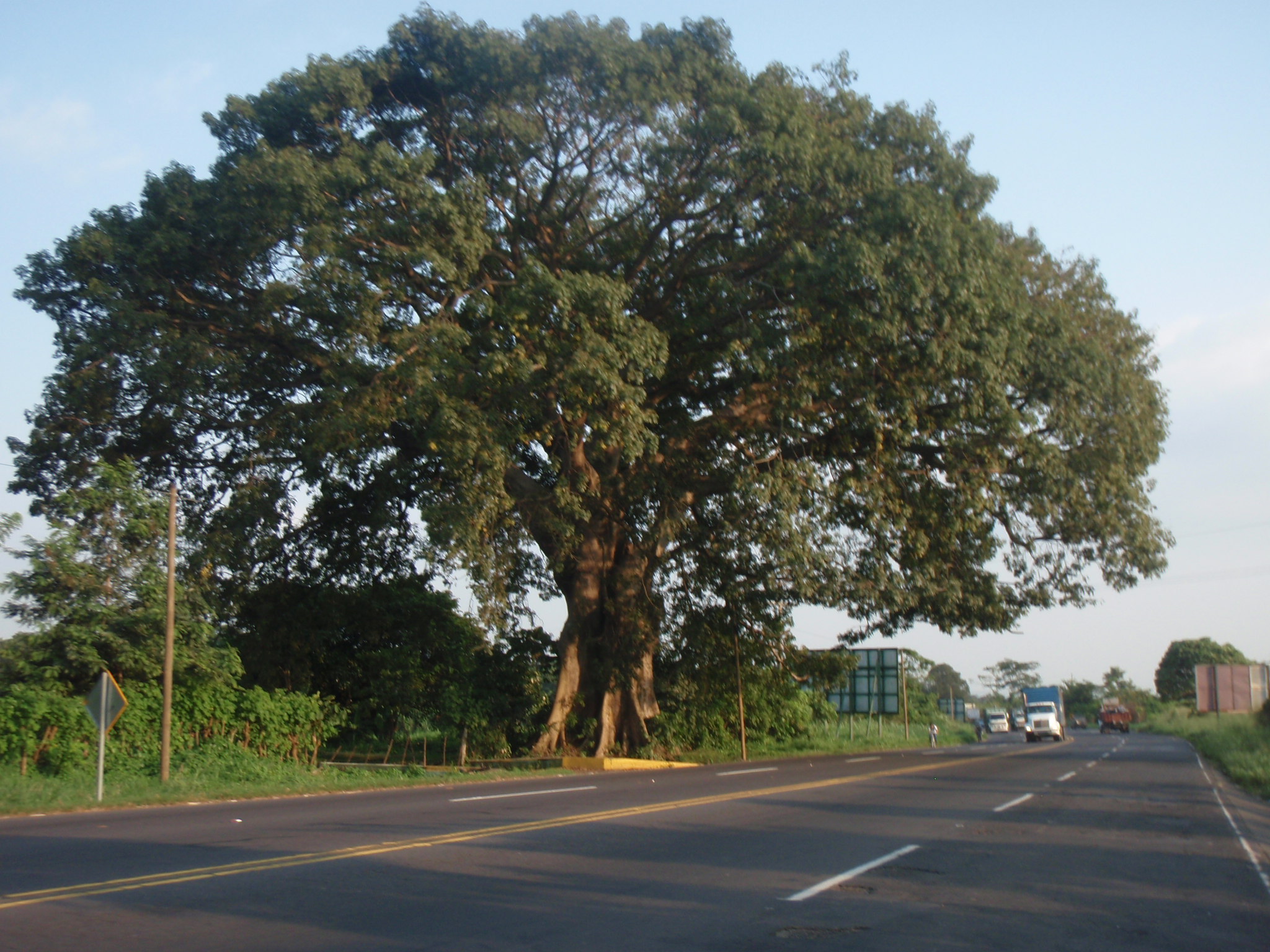
Another great thing are the huge tropical trees you find here along the road. Some of those trees rival the Giants up North in California, maybe not in height, but they definitely reach massive proportions, stretching out 30-40m in every direction, like huge bowls with a massive trunk!
After 130km, some 1500m elevation gain and 7h on the bike I reached the town of Escuintla, my goal for the day. I looked for a restaurant to get some dinner and drink plenty of water. I even got Internet access during dinner, so I could check email. And they accommodated my bike inside the restaurant by moving a few tables aside, letting me lean my bike and trailer against the wall, and moving the tables back!

As I was one of the only guests at the restaurant, the owners talked to me and took an interest in my project. Then they asked where I would stay for the night. “At some hotel or campground, if possible – don’t know yet.” That got them thinking…
Just around the corner from the restaurant is a hotel whose manager is friends with the owner of the restaurant. So he sent me there. Bueno, I rolled around the block and got to the hotel. Unfortunately they are sold out and have no available rooms, I was told. Just as I am about to leave again the restaurant owner shows up on his motor scooter and talks to his friend, the hotel manager. He tells him about my journey and the special bike I’m riding. So after a few minutes one thing is clear: They will find a place for me to stay here! Who needs a room when you have a tent?

I end up camping in a corner of a safely locked and guarded parking area. Since the hotel has a swimming pool, I can use the poolside shower and facilities. El agua es fria! I am warned, but who wants warm water when you have been sweating the whole day and look forward to cooling off anyway!

This is actually the second night that I am camping at a hotel with swimming pool and enjoying the amenities at a greatly reduced rate! Welcome to Guatemala…
November 17th, 2009
After arriving yesterday and spending an evening in Tapachula near the Guatemala border I will try to get to San Marcos (across the border) today by bus and then take another bus tomorrow morning to the trailhead of the Tajumulco climb.
I have created a new SPOT tracking page (see Links section) which should reveal my whereabouts for the next two days. Will not bring my laptop or much of anything else. Bike will stay here in Tajumulco. Should be back by Sunday evening or Monday morning.
Quick Update: Back in Tapachula Sunday evening; reached Tajumulco summit on a clear day, very nice hike (3h up, 1.5h summit rest, 1.5h down), but adventurous 4.5h bus return trip down almost 3000m. Check the photos on the PicasaWeb gallery!
November 14th, 2009

After coming down from Pico Orizaba I returned by bus via Puebla to Oaxaca, where I stayed another evening and night. This was a great experience, with vibrant city streets, plazas, cafes and restaurants on a Friday night. One interesting aspect about Oaxaca was how men would greet each other: They first shake hands, then pull close into an embrace where the right shoulders touch and they slap each other on the back with the left hand, then they shake hands again. I observed this several dozen times at various restaurants. I also thought it was funny how in some streets the lanes are crossing to the other side (like an “X” shape) so that all of a sudden you drive on the left side of the road, and after a km or so they cross back. I don’t know why this is done, but it was highly confusing for me as a cyclist.

Leaving Oaxaca to the South the road soon climbs up into some mountainous territory, and it pretty much stays like that all the way to Tehuantepec some 250km later. Either uphill or downhill, hardly anything in between; this must be heaven for motorcycles, but it’s very hard for the heavy weight touring bicycle.

At least I still felt the acclimatization advantage from Orizaba, which was great, like on extra Oxygen boost with every deep breath. Over those two days I covered 3000m uphill and 4500m downhill – I was now gaining all the energy back which I had put in when riding up into the Mexico highlands after Mazatlan 🙂 And there were some really long downhills, up to 900m (3000ft) at a time, where I felt like a motorcycle, effortlessly cruising at 50-65km/h and hardly touching the brakes for 10-15 minutes at a time.

Once in Tehuantepec the terrain levels out and the road is mostly flat. What a difference, you can just roll along with much less effort and actually ride near 20km/h average speeds again! That said, there was a new challenge: Wind! A very strong Northerly wind was blowing the last two days here. Since the route is initially East, this wind didn’t help much, it was straight from the left side. In gusts the wind was so strong that it actually blew me off the road into the grass several times! With traffic from behind I had to pay very close attention, especially on short stretches of the road which lacked a shoulder.

There seems to be strong wind frequently, as I rode past several wind farms in this area. One little town there is aptly called “La Ventosa”. At one time I felt a few drops of water on my skin; first I thought this might be from a passing car or truck, but then it started to full-on rain, despite clear blue sky up and around me! I thought this is weird, then looked upwind and noticed that several km to the North there was a large black cloud covering the mountain tops. Apparently the wind was so strong that it blew the rain falling out of this cloud all the way down into the valley – it literally rained sideways!
Once the road passes Zanatepec and Tapanatepec, it bends more towards the SE, so the N wind is more of a tailwind than from the side. So the last portions were actually quite pleasant, often with tailwind accelerating up to 35-40 km/h.
In 2 days I should reach Tapachula near the Guatemala border. From there it’s also fairly close to Tajumulco, the highest mountain in Guatemala and my 5th Panamerican Peak…
November 11th, 2009
Previous Posts