Well, yesterday wasn’t an “easy” day after all – after the first 150m hill right after the Teslin bridge with cold muscles at the start of the ride there were many more hills, for a total of 1600m vertical and 109km. While I dodged most dark rain clouds throughout the day, I got hit hard by rain 15km before Swift River:
The day had started very sunny, but also very hilly. Right after the Teslin bridge is a nice overlook:
At one point in the afternoon I was so hot that I went swimming with bike pants and jersey in the Morley River, just like I had earlier in the Yukon between Beaver Creek and Burwash Landing.
Dark clouds created beautiful scenery, with many shades of green, blue and grey. Wouldn’t have been so bad had I not gotten completely wet in the last hour of the ride…
Now that I have crossed the Continental Divide I have more favorable Westerly winds and dry forecast, so today’s ride to Watson Lake should be somewhat better…
After a restday and bike clean / tune-up in Whitehorse on Thursday I rode all the way to Teslin yesterday. That’s 184km! And since I was stupid enough in the morning to go in the wrong direction in Whitehorse for a while I added an extra 45 min and 12km for a total of almost 200km and more than 10hrs on the bike – my longest day so far. There was a good bit of headwind for the first couple of hours, which is why it took me all of the daylight hours to get here (by 11:30pm). In the late evening light I took a short 10sec video riding along Lake Teslin:
The sun paints spectacular colors in the evening. This combined with the beautiful nature landscape inspires the photographer. Here are two pictures, one crossing the Tesling River at Johnsons Crossing and the other arriving at Teslin at 11:20pm close to sunset.
Today Saturday I’m planning to take it a bit easier. After checking out the Teslin “Northern Wildlife Museum” I have “just” 106km to Swift River…
170km – 180km – 180km – 140km – 170km … those were the last 5 riding days since Fairbanks! (Fairbanks – Delta Jct – Tok – Beaver Creek – Burwash Landing – Haines Junction). Most rides were very hot and dry. At one clear creek I stopped and dipped into the cold mountain water, with shoes and bike jersey and all – the evaporation cooling helped over the next several miles.
A highlight of the journey so far was yesterday’s ride along Kluane Lake. I remembered this stretch from 10 years ago when driving up the Alcan in a rental car. Again, the refreshing and clear water invited to take a dip:
I also saw my first bear between Burwash landing and Destruction Bay near the lake. An adult Grizzly walked out on the road maybe 100m in front of me and stopped; so I stopped as well. When I stood up the bear ran back to the nearby bushes, then stopped and smelled to check things out. I walked my bike slowly and – just to be sure – pulled out my bear spray (not that I needed it, of course). The magnificent animal lingered a bit and then disappeared into the woods. A bit later I saw a Coyote about to cross the road (maybe 30m away), then turning around quickly when it noticed me. Nice to see more wildlife now.
Around 6pm I stopped by the airstrip where we had camped and waited to fly to Mount Logan basecamp two months ago in May. It was nice to see the folks again – but they denied my special cargo request due to insufficient tread on my back tire!
After another 3 hour ride a 15km, 400m downhill rush finished off yesterday’s ride into Haines Junction. Unfortunately I was still 10min too late for the restaurants close at 9:00pm, so I went to sleep hungry (way too many mosquitoes to cook) as most always on this trip! One more reason to have both a huge cinnamon bun and an apple fritter and lots of coffee and sugar for breakfast this morning…
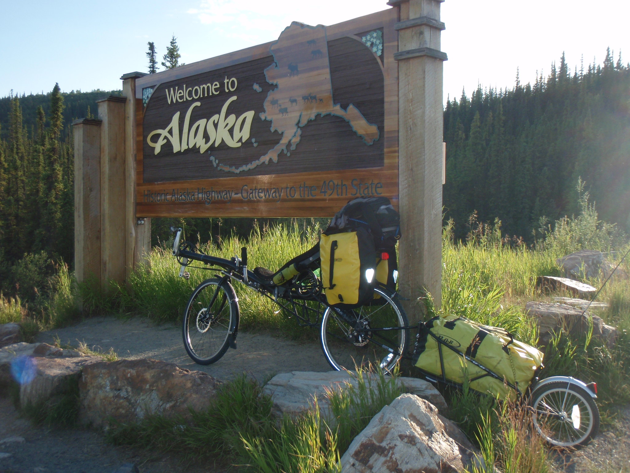
Hello from Beaver Creek, Canada! I’ve got a fast (wired) Internet connection, so I spent half of the morning uploading Alaska pictures, updating the Alaska page, creating a new (Canada) SPOT page, and enjoying good breakfast all the while 🙂 Except the uplink speed of these satellite Internet connections is so slow that I can’t upload the video I took last night from the ride right after the border (1m30sec HD video = 120MB would take more than 1 hr at the slow uplink speed…)
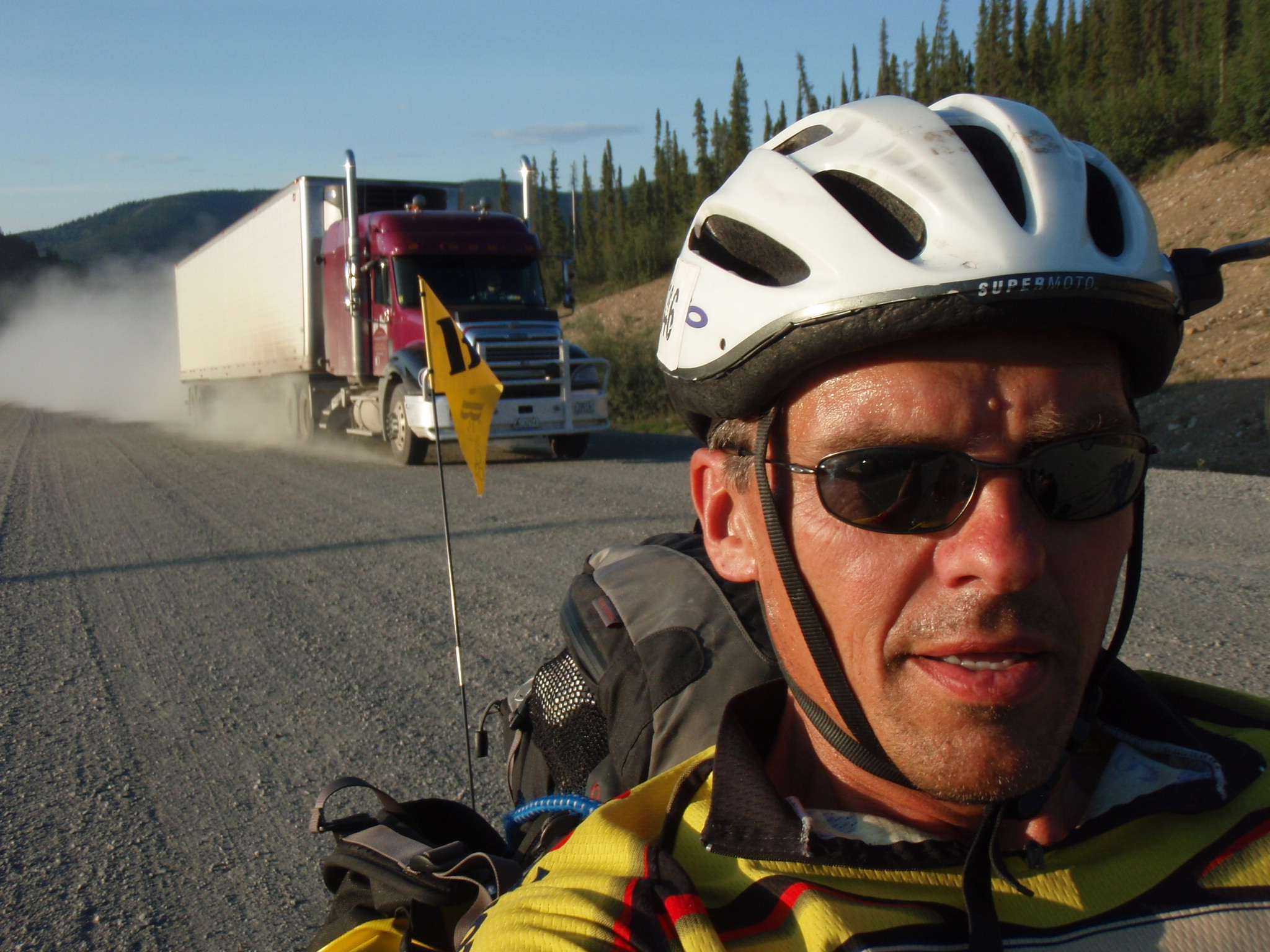
As mentioned in the last post, the light last night was truly spectacular. Apart from a 7km gravel section – they had a road sign “Extremely Dusty Conditions” – it was some of the finest riding I have ever done.
I had to ride slowly and carefully in the gravel and also endure the occasional dusting from a passing truck, but aside from that it was just magic.
I almost felt a bit melancholic to leave Alaska already; the weather up here has been very favorable and I truly enjoyed riding in the great state.
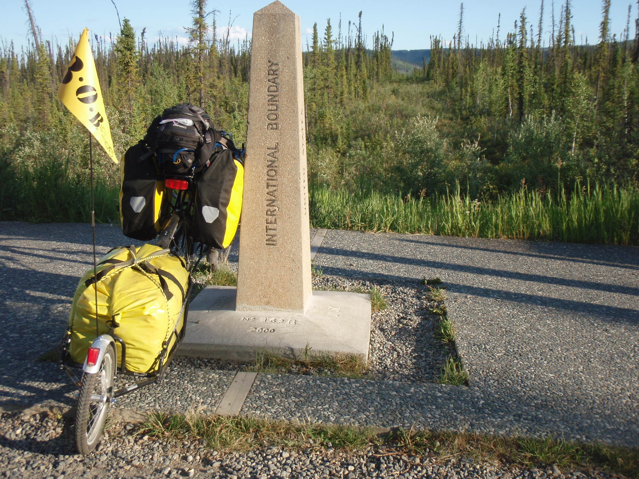
The Alaska – Canada border is marked by the 141st meridian; it’s a straight line cutting through the boreal forest some 1200km (I believe) all the way up to the Arctic Ocean.
Check out the entire picture library linked from the Alaska page.
Note also the link to the new Canada SPOT tracking page on the right side of the page.
I better get going – it’s going to be another hot day of riding, no rain since 2 weeks and more heat and sun in the forecast…
After 7 days on the Dalton Hwy (840km) and then 3 long riding days from Fairbanks via Tok to Beaver Creek (530km) I just arrived at the Canadian border. The Richardson Hwy (Fairbanks to Delta Junction) and then Alaska Hwy (Delta Jct to Tok to Canadian border) were mostly flat and smoothly paved – what a difference to the extreme hills and gravel of the Dalton Hwy. So a daily distance of 170-180km was doable in about 8 hrs of riding.
The last 3 days were mostly long straight stretches through the boreal forest, at times undulating hills along the side of the Tanana or tributary rivers and the occasional steel bridge. The water in those rivers was high and brown from recent heavy rains – however I have not had a single drop of rain while riding in all of Alaska! (I only had rain from a front passing over night through Fairbanks after the 90F hot restday, which was the hottest day in Fairbanks in 15 years!)
In Delta Junction the Alaska Highway ends at mile marker 1422. I am riding back down all the way to Dawson Creek, so more than 2000km total on the Alaska Hwy. (Currently at MM 1225.)
One of the highlights of the last day was the view into the Teslin National Wildlife Refuge – part of the largest protected wilderness area in the world (with Wrangell St. Elias NP, Kluane NP, Glacier Bay NP). For hundreds of km South of the Hwy there is nothing but protected wilderness, no roads, no buildings, no nothing! This reserve area is so big that it would cover almost all of Germany – such vast wilderness areas don’t exist in Europe anymore…
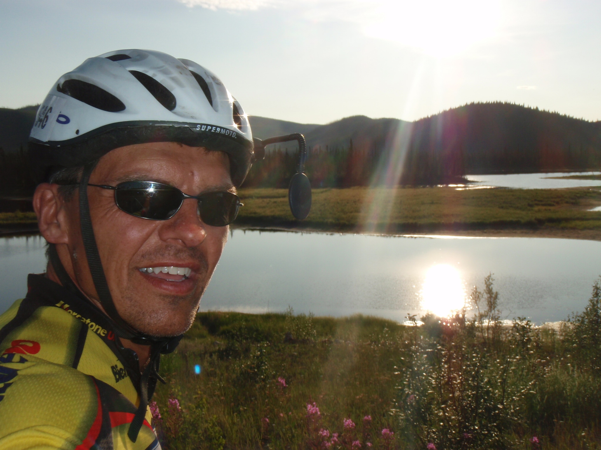
The ride between the two border posts (US, Canadian) late evening was absolutely incredible. Aside from a 7km gravel section with extreme dusty conditions the scenery and low sun light conditions were stunningly beautiful. Meandering creeks, sun-reflecting ponds with ducks and swans, green grass, trees and the snow-capped mountains in the background – my own shadow riding 30m next to me… Check out the pictures from the Alaska page!
I’ll close the SPOT tracking page and create a new one for Canada shortly…